Protecting people from natural disasters
- By Zhang Li
 0 Comment(s)
 Print
Print E-mail China Today, June 20, 2017
|
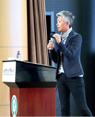
Professor Yang gives a lecture on disaster mitigation and emergency management to students and teachers at Beijing Normal University's Experimental Primary School. [Photo/China Today] |
It is not easy to predict natural hazards. The situation is especially complex in China as there are many types of natural hazards occurring in places with different geographical conditions, which makes the disaster prevention and reduction efforts more difficult.
To reduce the impact of natural disasters, Chinese scholars and experts are taking action. They are studying previous natural disasters and assessing the risk. Their research results are valuable information from which the Chinese government can make informed decisions. Professor Yang Saini, from the Academy of Disaster Reduction and Emergency Management (ADREM) at Beijing Normal University, is one of them.
A career in the science of disasters
Born in 1975, Yang began studying at Southeast University in Nanjing in 1993, where she completed her undergraduate degree and Masters. In 2000, she went to the University of Maryland, where she got her PhD degree. In 2006, she got a tenure-track position at Cleveland State University.
"My life was stable in the U.S. However, I felt I didn't want to settle into a routine," Yang recalled with a smile on her face.
In 2008, Beijing Normal University offered Yang a job and she accepted the invitation to join its National Key Laboratory of Earth Surface Processes and Resource Ecology. "I wanted to do something meaningful," she explained about how she made the decision.
Professor Yang studied bridge engineering during her undergraduate years, then traffic engineering for her Masters and civil engineering for her doctoral program. Therefore, she boasts interdisciplinary expertise.
After returning to China, Yang joined the ADREM, which focuses on scientific research into natural disasters, natural resources and global climate change, and cultivates experts in those areas. That was how Yang launched a career in the science of disasters.
Supporting decision-making
Yang is mainly engaged in infrastructure risk assessment and management, and community-based disaster risk reduction. She has been in charge of some national level projects. One of them was under the National Science Foundation of China, studying the cascade effect on a region by multiple natural disasters. Another example is a research project Yang led under the National Basic Research Program (also known as 973 Program), looking at the relationship between global change and environmental risks. She and her team members made great achievements in assessing the risk of infrastructure when a disaster strikes and applying relevant modeling.
Heavy rainfall hit Beijing on July 21, 2012. Yang, by utilizing a disaster impact analysis model created by her team, created a simulation of the scenario with the flooded streets and inadequate drainage systems. The model accurately showed the changes in traffic flow over the transport network throughout the whole process.
"Our research provides a theoretical basis for investing in resilient infrastructure," said Yang.
Another of Yang's stand-out achievements was to establish a model assessing the risks posed to the infrastructure network during natural disasters. Yang and her team analyzed the typhoon data from the past 60 years in Hainan Province. By creating a typhoon model, including the typhoon's characteristics, landing position and its size, Yang's team conducted research into the typhoon's impact on road functions and road transport, in order to make alternative emergency response plans.
"A good emergency response plan should be able to serve different parties," Yang explained. "For example, drivers can quickly know about possible traffic conditions during the disaster and choose the right way to go. The traffic management department can make plans in advance as they can predict the loss of transport capacities. A good emergency response plan can also guide emergency response, helping the decision-makers decide which sections of road should be fixed immediately and which sections can be set aside and dealt with later."
As the society and economy continues to develop and people's living conditions improve, it becomes increasingly necessary to address community-based disaster prevention and mitigation. Over the past few years, Yang has launched surveys and studies in communities and provided training to residents on how to create and use risk maps. "Our aim is to let people know where is safe and where is dangerous, and where the evacuation routes are when disasters strike," explained Yang.
Their research provides a theoretical basis for governments at various levels to make decisions when choosing locations for emergency shelters and planning for evacuation routes.


