China's last 'isolated land'
Chentang Town of China's Tibet Autonomous Region is located in a primeval forest region at the northern foot of the Himalayas, southeast of Mount Qomolangma.
It has Nepal's Taplejung County to the east, Sankhuwasabha County across a river to the south, Riwu Town of Dingjie County to the north and Dingri County to the west.
|
|
|
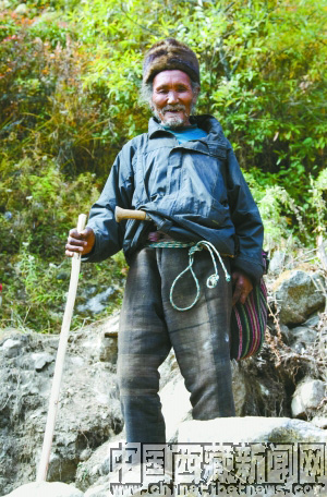
A senior man from Chentang Town, southwest China's Tibet Autonomous Region. [Photo: chinatibetnews.com] |
Chentang Town is 150 kilometers away from Dingjie County. It is about 16 kilometers wide north to south and about 20 kilometers long east to west, and has a 76 kilometer long borderline.
"Chen" means transportation and "Tang" means a road. Therefore, "Chentang" means "a road for transportation."
Overlooking the entire town while standing at the Moruotawala mountain pass, you will be surprised to find that the Pengqu River and Gama Zangbo River meet at Chentang Town and vividly "reproduce" a "U-shaped turn in the Yarlung Zangbo River."
Chentang is like a beautiful village "hung" on a hillside.
During the 1990s, a member of the National Committee of the Chinese People's Political Consultative Conference (CPPCC) on behalf of Chentang Town twice proposed to higher authorities at the Tibet Autonomous Region Political Consultative Conference dispatch a helicopter to Chentang Town, in order to solve the town's problem of inconvenient transportation.
Thankfully, the construction of the Chentang Road, paid for by the Central Government, formally started in 2001. The construction, however, faces huge difficulties and is progressing very slowly due to complex topography and harsh climate in the area.
At present, the road under construction has reached Nadang Village in Chentang Town and the construction of the entire road is expected to be completed in one or two years.
Locals said that Chentang is very beautiful. In April and May, the hills are covered by flowering azaleas and the Tulong Lake is as beautiful as a dream.
 0 Comments


